SUGGESTIONS OF NEW ENTRIES and COMMENTS
are always warmly welcome - tmciolek@ciolek.com

31 July 2006

Parthian Stations by Isidore of Charax

http://www.parthia.com/parthian_stations.htm

TABLE OF CONTENTS [Added]
Wilfred H. Schoff's original 1914 London edition includes the following sections:

Parthian Stations by Isidore of Charax
Journey Around Parthia by Isidore of Charax
Description of the World by Isidore of Charax
From an Unknown Work by Isidore of Charax
Commentary by Wilfred H. Schoff
Notes by Wilfred H. Schoff
Parallel Passages from the Chinese Annals from Hirth, China and the Roman Orient
A Modern Account from Curzon, Persia, I
Trade Routes of Modern Persia from Curzon, Persia, II

Online since 28 March 1998
Copyright (c)1998-2006 Edward C. D. Hopkins


Please note that the above details were correct on the day this post was published. To suggest an update, please email the site's editor at tmciolek@ciolek.com

Trade routes in the Sahel and Sahara (XVIth to XIXth centuries)

http://www.unesco.org/webworld/memory/committee_tashkent_proposals.htm#TraderoutesintheSahelandSahara


Institution : Faculty of Philosophy and Human and Social Sciences (CEFRESS), Amiens
Project status: Preliminary proposal submitted to the French National Commission
Content : Field study in the Sahel/Sahara region: interviews with village communities, collection and translation of local manuscripts and oral sources (Algeria, Mali, Mauritania, Morocco, Niger and Senegal)
Budget : FF 1,011,000
Remarks : This is more of a research project

Pending requests and project proposals [UNESCO, Memory of the World]
discussed during the Third Meeting of the International Advisory Committee
Tashkent, 29 September - 1 October 1997


Please note that the above details were correct on the day this post was published. To suggest an update, please email the site's editor at tmciolek@ciolek.com

Alpine Roman Roads: Stanford Alpine Archaeology Project

http://traumwerk.stanford.edu/archaeolog/2006/07/roman_roads_in_the_alps_stanfo.html

In 1994 the Stanford Alpine Archaeology Project began research to examine Alpine Roman Roads in the Grand-St-Bernard pass between Aosta, Italy and Martigny, Switzerland. This research is directed by Dr. Patrick Hunt, Classics Dept. Stanford University and has been conducted under the auspices of Stanford and the Office du Recherche Archeologique, Valais, Switzerland, and the Soprintendenza for Archaeology of the Valle da Aosta, Italy.


Please note that the above details were correct on the day this post was published. To suggest an update, please email the site's editor at tmciolek@ciolek.com
28 July 2006

German Amber Routes

http://en.wikipedia.org/wiki/Amber_Road

German Amber Routes

Source of the map: Joannes Richter - "Spelling Thee, U & I - Introducing into the art of amber trading & Initiation in the great Androgyne Religion" (pdf file)

http://www.joannesrichter.homepage.t-online.de/Androgyn/SpellingTUI.pdf


Please note that the above details were correct on the day this post was published. To suggest an update, please email the site's editor at tmciolek@ciolek.com

27 July 2006

The Northern Lights Route - The Trade Route to the White Sea

http://www.ub.uit.no/northernlights/eng/whitesea.htm

Equipped by London merchants of The English Company of Merchant Adventures for the Discovery of Lands, Territories, Isles, Dominions and Seignories Unknown, three ships sailed out of the river Thames in May 1553. The vessels headed north with the intention of finding the one thing that had been talked about in England for decades: the discovery of the sea route leading to Japan, China and India - the Northeast Passage. The English not only dreamed of immense riches in the Far East. They also believed Russia's northern passage could be quicker and safer than the trade routes which the Spanish and the Portuguese had discovered and taken control of.
[...]
In late August 1553, Richard Chancellor reached the White Sea, where he and his crew were welcomed with open arms by local Russian officials. [...] Regular trade was conducted with northern Russia from 1557 onward.
When Sweden gained dominion over the Baltic harbors that exported Russian products, the White Sea became the only alternative trade route to use between the European seafaring nations and the Moscow czardom. Most trade with Russia moved northward, therefore, and the czar had built a large port - New Kholmogory (called Archangel from 1613) - for the export trade in 1584.


Please note that the above details were correct on the day this post was published. To suggest an update, please email the site's editor at tmciolek@ciolek.com

Map of Silk Road in Gansu, China

http://www.chinahighlights.com/silkroad/map.htm

Gansu silk routes


Please note that the above details were correct on the day this post was published. To suggest an update, please email the site's editor at tmciolek@ciolek.com

Trade Route Map of Ghana Including Kwawu

http://www.scn.org/rdi/kw-map6.htm

Trade routes in Ghana
A sketch map of showing historical trade routes through Kwawu.


Please note that the above details were correct on the day this post was published. To suggest an update, please email the site's editor at tmciolek@ciolek.com

25 July 2006

Materials on Early Chinese Maritime Trade and Imperialism

----------------------------- start of forwarded message -------------------------
Date: Sun, 9 Jul 2006 20:25:48 EDT
Sender: H-Net list for Asian History and Culture
Subject: H-ASIA: Materials on Early Chinese Maritime Trade and Imperialism

H-ASIA
July 9, 2006

Materials on Early Chinese Maritime Trade and Imperialism
*****************************
From: w.d.oneil--at--POBOX.COM

Here is a short of list of some recent material relating to Cheng Ho's
(Zheng He) and other Chinese voyaging in the 14C and 15C, as well as other aspects
of medieval and early modern Chinese maritime trade and imperialism that may
be of interest to some members:

Edward L. Dreyer, _Zheng He: China and the Oceans in the Early Ming
Dynasty, 1405-1433_, ed. Peter N. Stearns, Library of World Biography
(New York: Pearson Longman, 2006).
http://www.amazon.com/gp/product/0321084438/qid=1152426016/sr=1-1/ref=sr_1_1/1
02-6109517-5020169?s=books&v=glance&n=283155

Hamashita Takeshi, "Ryukyu Networks in Maritime Asia: An Introduction
to the Rekidai Hoan," _Kyoto Review of Southeast Asia_, 3 (Mar 2003),
http://kyotoreview.cseas.kyoto-u.ac.jp/issue/issue2/index.html

Geoffrey Wade, "Ming China and Southeast Asia in the 15th Century: A
Reappraisal," Asia Research Institute Working Paper Series No. 28,
Jul 2004, www.ari.nus.edu.sg/pub/wps.htm

Geoffrey Wade, "The Pre-Modern East Asian Maritime Realm: An Overview
of European-Language Studies," Asia Research Institute Working Paper
Series No. 16, Dec 2003, www.ari.nus.edu.sg/pub/wps.htm

Geoffrey Wade, "The Zheng He Voyages: A Reassessment," Asia Research
Institute Working Paper Series No. 31, Oct 2004,
www.ari.nus.edu.sg/pub/wps.htm

Christopher Wake, "The Great Ocean-going Ships of Southern China in
the Age of Chinese Maritime Voyaging to India, Twelfth to Fifteenth
Centuries," _International Journal of Maritime History_, 9, No. 2
(Dec 1997): 51-81.

Christopher Wake, "The Myth of Zheng He's Great Treasure Ships,"
_International Journal of Maritime History_, 14, No. 1 (Jun 2004): 59-75.

Southeast Asia in the Ming Shi-lu, http://www.epress.nus.edu.sg/msl/

William D. O'Neil
----------------------------- end of forwarded message -------------------------


Please note that the above details were correct on the day this post was published. To suggest an update, please email the site's editor at tmciolek@ciolek.com

23 July 2006

Nineteenth Century Trade Route between Bhutan and Assam

http://www.bhutanstudies.org.bt/journal/vol13/13-1.pdf

Indrajit Ray and Ratna Sarkar. 2005. Reconstructing Nineteenth Century Trade Route between Bhutan and Assam: Evidences from British Political Missions. Journal of Bhutan Studies Vol. 13, Winter 2005.

[...] the Bhutanese ponies were spirited, and understood
their duties perfectly. In the line of the march, they proceeded
orderly especially when the road was uneasy. They could
march in such roads at a speed of about 2.5-3.2 km per hour.
“In difficult ascents”, he observed, “they are assisted by
pushing up and in descents they are equally assisted by
vigorously pulling at the tail.” [...] Ponies
and mules apart, sheep, goats and asses were also found
plying in this route with cargo. Available information suggests
that the Tibetan breeds were superior in this class of beasts.
The Tibetan sheep, for example, could carry a load of 15-20
kg each as against the carrying capacity of 6-12 kg for the
Bhutanese sheep and goat. The ass was, however, the most
robust animal capable of carrying about 40 kg each. But they
were employed exclusively for carrying salt in this route. The
Kumpas of Tibet also employed the ewes and the yak as the
beast of burden but their uses were limited.


[this reference was kindly supplied on 21 Jul 06 by vajra vajra (darkvajra--at--yahoo.com)]


Please note that the above details were correct on the day this post was published. To suggest an update, please email the site's editor at tmciolek@ciolek.com

Historic trade routes from the time of the Tibetan Empire at its zenith to modern times

http://www.tibetancoins.com/III%20Tibetan%20Trade.html

The map3 [in Lamb, A., "British and Chinese Central Asia", 1960, Map adapted from Sketch Map, p. 3. - tmciolek] shows the historic trade routes from the time of the Tibetan Empire at its zenith to modern times. These routes can be broadly grouped as shown below.

1. The eastern route via Tachienlu to China.

2. The northeastern route via Koko Nor to China, the Turks and Siberia.

3. The northwestern route via Ladakh: to Khotan, Kaskgar, Kucha and trans-Oxania: to Bokhara and Samarkand.

4. The trans-Himalayan routes: to Ladakh, Kashmir, Indian States, Nepal, Sikkim, Cooch Behar, Bhutan, Assam.4

1. The Eastern Routes

The main road to China goes from Lhasa to Tachienlu via Gyam-do, the capital of Kong-po, and then on through Cham-do. From the latter village there are two routes to Tachienlu one going to the east through Kan-ze, the other southeast through Ba-tang and Li-tang. Tachienlu is on the border between Tibet and China.5 [...]


[this reference was kindly supplied on 21 Jul 06 by vajra vajra (darkvajra--at--yahoo.com)


Please note that the above details were correct on the day this post was published. To suggest an update, please email the site's editor at tmciolek@ciolek.com

04 July 2006

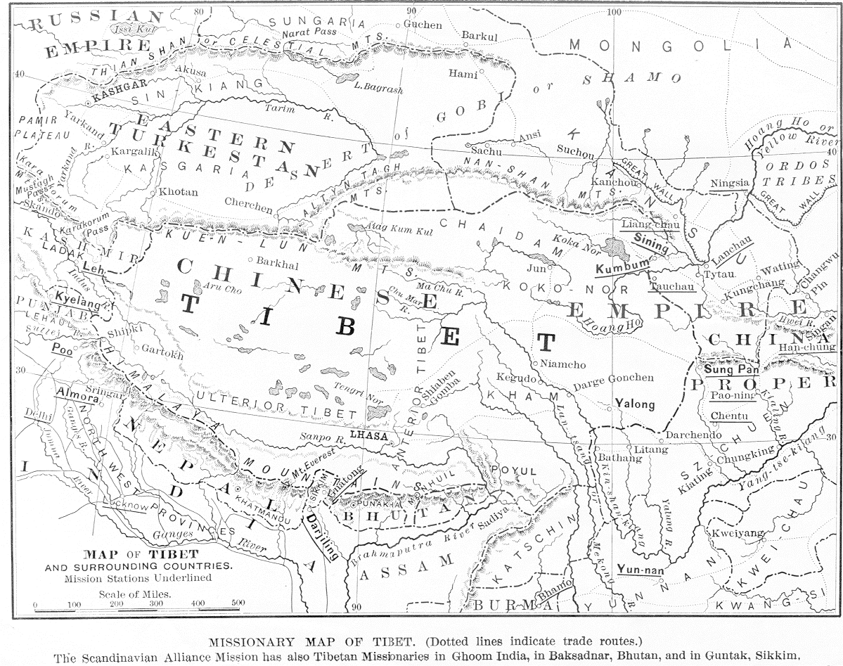
Tibet and the adjacent regions - trade routes in the 19th c.

http://www.ciolek.com/WWWVLPages/TibPages/tibet-map-1897.html

Tibetan trade routes

Shaw, F. Becker. 1897. Missionary Map of Tibet (dotted lines indicate trade routes) / The Scandinavian Alliance Mission has also Tibetan Missionaries in Ghoom, India, in Baksadnar, Bhutan, and in Guntak, Sikkim. In: "The Siege of Tibet," The Missionary Review of the World, vol. X (n.s), February 1897, pp. 91-95 (The Map is printed opposite p. 92).


Please note that the above details were correct on the day this post was published. To suggest an update, please email the site's editor at tmciolek@ciolek.com